Homeland security
Border security includes both land and maritime borders and transportation security, including aviation and maritime transportation
Homeland Security will consider:
- New sensors.
- Existing sensors.
Data provided by all sensors must be used for data base generation and data fusion
The border control system includes the following subsystems:
- Communications: identification with RF gonio
- Electronic Warfare and Intelligence (Elint, Sigint): identification and localization with UAV
- Radar: Border and coastal recognition
- Image: Analysis with LIDAR, IR/Optical
- UAV and Manned platform
- Command & Control

COSTAL SURVEILLANCE
BORDER SECURITY
AIRPORT GROUND SECURITY

PIPELINES AND OIL PLATFORMS SECURITY
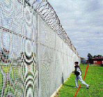
PERIMETER INTRUSION DETECTION SYSTEMS
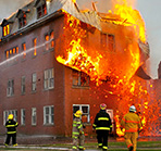
FIRE PREVENTION SYSTEMS
ANTI IED Land monitoring: PNRM Project
Anti IED Techniques by terrain image processing and multiple sensors data fusion.
Applications
- Land, Border, Port security
- Ecological Monitoring,
- Lazio Innova: S3T Project
- Emergency Management
- Smart Farming
HS LAND MONITORING
- Image analysis: Lidar, Opto, IR

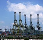
VESSEL TRAFFIC MANAGEMENT AND INFORMATION SYSTEM (VTMIS) –FOR CALLAU HARBOUR
1. SOFTWARE FOR VTMIS;
2. SENSORS: Radar,radio, Electro-optic long range camera with Tracking system, AIS Base Station, Aids To Navigation, Weather Station, Training Module, HW and furniture’s for Control rooms
3. COMMUNICATION/ NETWORK
4. C&C COMMAND & CONTROL

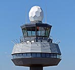
LAND SURVEILLANCE: Airports
- Mid & short range radars,
- Wave guide fencing system,
- Electro-optic subsystem
- Command and Control
- Discover & alarming

LAND SURVEILLANCE: Pipeline
-
Wave guide fencing system for pipeline protection
